Nei Pori
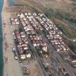
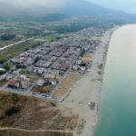
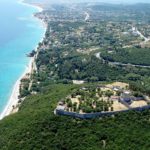
Nei Pori is a seaside village in Pieria, with 733 inhabitants, according to the 2011 census. The main occupation in the village is the tourist business. It is built on an urban plan, as it has large streets and squares. The distance from Katerini is 43 km. Their coast is the southern coast of Pieria, next to the traditional settlement of Old Poreos and the extensive wetland, in the northern part of the Peneos Delta. This mountainous village is constantly being renovated as a summer resort.
The earliest name of the Pori was Purlya, a Slavic word (prlja), meaning dirty. The name Purlya became Pori in 1926.
The name Pori of the village came from a version of the word ‘Pori’, meaning passage. Indeed, the village was built in 1775 during the desertion of Paliochora.
Another version states that the name of the Pori came from the “gate” which means calf, because the mossy part was thriving in calves. The other version says the Pori refer to the money and the economic boom of the Paliohori area.
According to tradition, in the antiquity there was a half-god, Poros. He fell in love with him and gave his name to the place.

Platamon Pierias
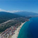
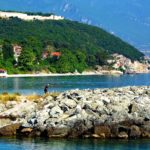
Platamon is a municipal apartment and settlement of the Municipality of East Olympus. It is located in the Prefecture of Pieria, at its southern end, at the foot of Mount Olympus. Bordering north with Nea Panteleimonas and south with New Poires. It is 38 km from Katerini and 48 km from Larissa. Its population is 2,013, according to the 2011 Census.
Platamon was an autonomous community until 1999, when he joined the Municipality of East Olympus. According to tradition, it owes its name either to the many planets lying in the area or to the wide sandy beaches.
Historically, the inhabitants of Platamonas are mainly natives, who originate from Paleo Panteleimonas (7 km north) and refugees. After the Asia Minor Catastrophe of 1922, Platamonas and the area south of the church (Metamorphosis), refugees settled, mainly from the wider area of Constantinople, whose activities are due to a large part of the later cultural and economic development of Platamonas. Known Families of Refugees, now in the fifth generation, are the Deligiannis family, the Nisso family, the Anastasios family,
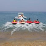
The inhabitants of Platamonas are mainly involved in tourism, as the area is famous for its award-winning beaches, fish taverns and bars. There are luxury hotels, rooms to let and camping. And also many shops with folk art.
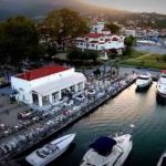
Platamonas is also the main advantage of its Port. A Marina of high specifications that can berth up to 125 boats. But also 10 Mega Yachts because of its 5 meter draft. The harbor – tourist shelter of Platamonas has an advantageous location in the Aegean because it is 62 miles from Skiathos, 60 miles from Thessaloniki and 30 miles from Halkidiki.
It has banks, a post office, a clinic, a cultural club, a football field and a high school, which serves the students of the surrounding settlements (Panteleimon and Resource). There is the Platamonas-Pontos-Panteleimonas Athletic Association, under the name “Poseidon”.
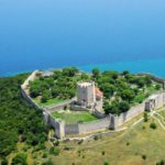
In the summer the population reaches 20,000 due to the many tourists. The tourists who choose Platamonas, and since they are the most important attraction and the most beautiful area along with N. Poros in the East Olympus apartment and not only, are mainly from the Eastern countries. Platamonas is also the summer resort of Larissa. Above Platamonas dominates the Venetian castle. The settlement is 7 km away from the traditional settlement of Palaios Panteleimonas, a popular destination due to the view of the many restaurants and hostels.
Between Platamonas and Neos Panteleimonos, the ancient city of Herakleia is believed to have flourished. Today, Platamonas, along with Nea Panteleimonas and the Northern Poros, are a focal point for commerce, tourism and transport. Their inhabitants, due to their common origin (P. Panteleimon), are calling for the creation of a new municipality, called “Platamon”.
The original name of the city in antiquity was Heraklion or Iraklia. The later story of Platamon is the same as his famous castle. The castle survives in a very good condition and is used for summer cultural events.

Olimpos
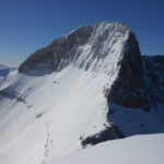
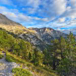
Olympus is the tallest mountain in Greece known worldwide for its mythological background, as at its peak (Mytikas-2918 m) the Twelve “Olympians” were inhabited by gods according to the religion of the ancient Greeks. It is also the second highest mountain in the Balkans (after Rila in Bulgaria), but also across Europe from the Alps to the Caucasus. Its compact mountainous volume is overwhelming in the limits of Macedonia and Thessaly, with a series of high peaks plunging deep ravines around which an area of particular biodiversity extends. In order to protect this unique heritage, it was declared in 1938 as the first National Park of Greece.
Each year, thousands of nature lovers visit Mount Olympus to admire the charm of nature and enjoy the tour of its slopes and the conquest of its peaks. Organized mountain shelters with a variety of mountaineering and climbing routes are available to visitors who want to explore its beauties. A classic starting point is the town of Litochoro at the eastern foothills of the mountain, 100 km from Thessaloniki, where at the beginning of each summer the Mountaineering Olympus Marathon ends. For the etymology of the “Olympos”, various versions have been expressed (sky, brilliant, tall, rock, etc.). In one version, the word Olympos is a pre-Hellenic toponym of an unknown genus, whose original meaning should be simply “mountain”. Mount Olympus, the highest mountain in Greece, is located on the south-western borders of Macedonia with Thessaly, defining the borders of the prefectures of Pieria and Larissa (coordinates 40 ° 05’N 22 ° 21’E). The effects of rain and wind combined with the often violent forces of nature have mitigated the current form of Mount Olympus, which proudly rises as a giant tower at almost 3,000 meters, with no surrounding mountains questioning its sovereignty. It is located only 18 km from Litochoro beach and so many adventures manage to combine the snowy peaks on the same day with a swim at the Olympic coast.
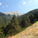
The boundaries of the mountain extend almost circularly on a perimeter of 150 km, with an average diameter of 26 km, as follows: in the northwest, starting from the village of Kokkinoplou, Makrirema divides Mount Olympus from the mountain mass of Bulgaria and in the northeastern foothills we meet the villages of Petra, Vrontou and Dion, while on the eastern side there is the small town of Litochoro, where the gorge of Enipea (Vithou), which cuts in the middle of the mountain, ends. On the southeastern side, the Ziliana ravine is a natural boundary between Kato Olympus and the southwestern foothills of the villages of Sykamineas and Karya. To the west the boundaries are defined by the Monastery of Agia Triada Sparmos and the village of Pythio.
On the foot of Olympos stretches Xirokambi, a low vegetation and micro-zone, and to the east the fertile plain of the Municipality of Dion, which crosses the streams of Olympus, before reaching the Thermaic Gulf.
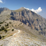
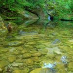
Olympus is undoubtedly the most popular mountain in Greece. Its impressive height, its fabulous charm and easy accessibility make it a pole of attraction for thousands of visitors from all over the world. The roads and paths that cross the mountain range, a network that is preserved in its majority, gives the hiker and the visitor who does not have special mountaineering interests or knowledge the opportunity to experience Olympus, the flora and fauna and the Its natural beauty. The most important is the E4 European Route that runs west from Litochoro to the peaks, through the Enipea Gorge. There is also the O2 National Path that connects the peaks to the south with Pelion.
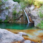
In many places there are seating areas close to springs and fountains that offer moments of relaxation and meditation to visitors. The Forest Service (Department of Forests of Pieria) has posted information signs on the National Forest map and useful instructions. Guests who have plenty of time at their disposal, ideally can climb the top of the second route and get off from the first, overnight stay in the shelters.
For climbers Olympus is a privileged place. There are well organized rides and hospitable shelters. The mountaineering routes at Olympus start at Litochoro, Dion and Petra. The summer ascents in the mythical mountain of the gods usually begin in early June and end at the end of September. It is the time when the shelters under the peaks are open and the weather allows a climb without the snow equipment and mountaineering experience that winter requires. The climb to the high peaks during the winter season can only be done by experienced mountaineers, for whom there are also challenging climbing routes on steep slopes.
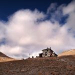
The two most beautiful routes for the exploration of Olympus start from Litochoro and reach to the tops of the mountain. The first one follows Enipea’s ravine and the visitor after about five hours of hurrying walk, after passing the Monastery of Agios Dionysios, arrives at “Prionia” (altitude of 1.100m) where an old sawmill was operating and today there is a restaurant for eating, Source and car parking places. In the same location, in the “Prion”, you can reach an alternative by car after an 18 km journey (there is a pavilion where information on the national park is provided at its entrance). From the “Prion”, following the well-marked European Path “E4” in about two and a half hours, the climber arrives through a path of unique beauty in the main shelter of Olympus, “Spilios Agapitos” (altitude 2,100m) where he can rest, To eat and overnight, which is the most common solution. From the sanctuary continues the E4 trail leading to the peaks of Mount Olympus in about two and a half hours.
On the road to Prionia at 10o km from Litochoro, at Stavros, there is the shelter “Dim. (944m altitude) that works, after the construction of the road, mainly as a restaurant-café. Along the road there are places where one can stop and enjoy the scenery. Four kilometers before the end of the road to Prionia, in the location “Gortzia” (1.120m), where there is a car park, begins a second, alternative path leading to the peaks of Olympus. From this point, after about five hours of hiking, after passing consecutively from the positions of “Barba”, “Petrostrugga”, “Skourta” and “Neck”, the climber reaches the “Plateau of Muses” at an altitude of 2600m where he can rest in Two shelters that are there, “Gios Apostolidis” and “Christos Kakalos”. From here, the route to the top of the mountain is relatively easy and can be reached in about an hour.


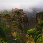
Meteora
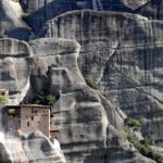
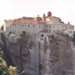
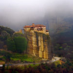
Meteora is a complex of huge, dark rocks of sandstone, rising out of Kalambaka near the first hills of Pindos and Hassia. The Meteora monasteries, built on the top of some of the rocks, are today the second most important monastic complex in Greece, after Mount Athos. Of the thirty that have historically been, there are currently only seven, which since 1988 have been included in the UNESCO World Heritage List.
The average altitude is 313 meters.
Studies show that the rocks formed about 60 million years ago during the Paleogenic Period. Disintegration, erosion and earthquakes then gave them their present shape.
The creation of the geological landscape, although it has occasionally occupied many Greek and foreign geologists, has not yet been clearly interpreted. It is interesting that neither Greek mythology nor the ancient Greeks, nor any foreign historian has been mentioned in this area.
According to the theory of the German geologist Alexander Philipon, who visited Greece in the late 19th century, the creation of these huge boulders was due to a deltoid cone made of river boulders and limestone rocks that for millions of years poured into a sea area covering at that time Thessaly. The geological changes of the ages lifted and excited this part when the waters of the Aegean were removed. Thus, later in the tertiary period that formed the Alpine ridges of the Pindus mountain range, this cone was cut off from its compact form, creating smaller ones, those present today, and among them the valley of Pinios river.
Inside these rocks is the cave of Theopetra.
The wild and inaccessible landscape was a convenient place for the Christian ascetics who settled in the area in a time that is not exactly known.
According to various opinions of Byzantinologists it is claimed that it began before the 11th century. Other historical information, however, mentions the first ascetic settler of a Barnabas who in 950-970 founded the very old Covenant of the Holy Spirit. The founding of Metamorphosis (1020) was followed by the Cretan monk Andronikos and in 1160 the Skati of Stagon or Doupiani was founded. After 200 years, the ascetic Barlaam founded the Monastery of the Three Hierarchs and the All Saints, and later unknown priests created the Monasteries of the Holy Trinity, Agios Stefanos, Ypapanti, Rousanou or Arsanou, St. George of Mandila, Agios Nikolaos of Anapassas , Panagia tis Makanis, Agioi Theodoroi, Agios Nikolaos of Bantova, Agioi Apostoloi, Aghios Gregorios, Aghios Antonios, Pantokratoras, Aghia Moni, Prodromou, Monastery of Ypsilotera or Kaligrafon, Modestos, Alysos , T Apostle Peter, Saint Demetrius, Kalistratos, Taxiarches and John of Bonilla.
The name Meteora is attributed to the founder of Megalo Meteora Monastery, Saint Athanasios the Meteorite, who named Meteoros Platis Lytos, which he first ascended in 1344. In general, monastic life in Meteora recorded a recession in the years of its decline and fall Byzantine empire and the consequent Ottoman conquest of Thessaly in 1393. However, from the end of the 15th century and especially in the 16th century, Meteora knew their greatest prosperity as new monasteries, monasteries and monasteries were founded, which adorn century with unique art paintings.
Over the years, this monastic state has begun to be strengthened by monks to reach the peak of its peak in the 17th century. However, from this period the decline begins and today only the monasteries of Metamorphosis, Varlaam, Agios Nicolaos of Anapaşa, Rousanou, Agia Triada and Agios Stefanos, as well as some parts of some others, can be found. Remainders have disappeared.
Meteora, due to their morphology, offered during the Ottoman domination an ideal retreat for monasticism and saved monuments of civilization and works of post-Byzantine art. At the beginning of the 19th century many monasteries were ravaged by Ali Pasha’s army.
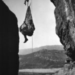
In the 1920s scales and tunnels were carved on the rocks, making the monasteries accessible from the neighboring plateau, so the traditional method of communication and refueling of the monasteries with ladles, ropes, pulleys and baskets was gradually abandoned.